
Need a map of the United States? Whether you’re a teacher planning a geography lesson, a student studying for a test, or just someone who needs a clear reference map, finding a good, printable US map can be incredibly useful. At amazingprint.net, we offer a variety of Free Us Maps To Print that cater to different needs. These maps are readily available in PDF format, ensuring easy download and compatibility with any standard printer.
 Printable blank United States Map
Blank US Maps for Printing
Sometimes, the simplest map is the most effective. Our printable blank US map is perfect for quizzes, coloring activities, or any task where you need to fill in the details yourself. This map provides a clear outline of the United States, allowing users to add state names, capitals, or any other geographical information as needed. It’s an excellent tool for hands-on learning and geographical exploration.
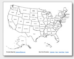 Printable US map with state names
US Maps with State Names for Printing
For those who need a bit more guidance, our printable US map with state names clearly labels each state. This map is ideal for quickly identifying states, studying state locations, or as a reference guide. It’s particularly helpful for students who are just beginning to learn US geography and need a visual aid to recognize state boundaries and names.
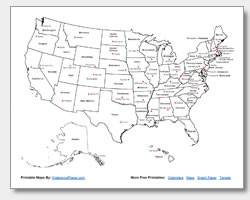 Printable US map with state names and capitals
US Maps with State Capitals for Printing
Taking your geographical knowledge a step further, our US map with state and capital names is a comprehensive learning tool. This map not only shows state names but also includes the names of each state’s capital city. It’s perfect for students preparing for geography bees, travelers planning trips, or anyone wanting to enhance their understanding of US state capitals. Knowing the capitals is a key aspect of US geography, and this map makes it easy to learn and remember them.
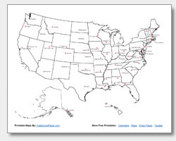 Printable US map with state capitals
Printable State Capitals Location Map
For a more visually focused study of capitals, the printable state capitals location map is invaluable. This map uses stars to pinpoint the exact locations of state capitals within each state. This visual representation helps to understand the geographical distribution of capitals across the country and is a great resource for visual learners. By seeing the capital locations, students can develop a better spatial understanding of US geography.
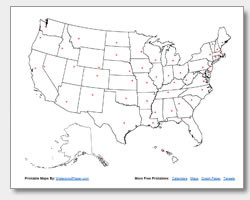 State capital location map
How to Use Your Free Printable US Maps
The uses for these free US maps to print are virtually limitless. Teachers can utilize the blank maps for classroom activities, asking students to label states or capitals as homework or in-class exercises. The maps with names are excellent study guides, and the capital location map can make learning more engaging and intuitive.
Beyond education, these maps serve as quick desk references for anyone needing to look up a state location or capital city. Whether you’re planning a road trip, working on a project, or simply curious about US geography, our collection of free printable US maps at amazingprint.net is here to help. Download, print, and explore the United States today!